Escape to the natural wonders of Great Himalayas, just southeast of Manali, for an unforgettable experience. Hamta Pass trek is the beginner's delight in every way easy access, dense pine forest, beautiful meadows, adrenaline pumping river crossings and a high altitude mountain pass called Hamta. It got its name from the Hampta village and shepherds and villagers used this pass to enter in Lahaul Spiti valley of Himachal. This was a traditional alternative route between Lahaul and Kullu Valley before the road was made over Rohtang Pass.
Hampta Pass is a moderate trek with a scope of mixing a lot of other adventure activities to suit varying duration and interest of trekkers. It starts from the Prini village and takes us to the majestic foothills of The Great Himalayas, the Pir Panjal Range which is the largest range of the lower Himalayas. Over this trek one will see different hues of nature as you gain altitude from thick green pine forest to awe-inspiring view of Mt. Deo Tibba and Mt. Indrasan and their snaking down glaciers to the barren landscape of Lahaul and Spiti valley.
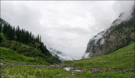
This trek connects two valleys Kullu and Spiti, so one can get different sort of landscapes. Kullu is full of vegetation and greenery and in contrast, Lahaul valley is completely rocky and sandy with brown mountains with snow-clad peaks. Here scenario of nature changes every day
You will arrive in Manali at 6:00 AM. Thereafter, you will move to the Hotel and take rest till Lunch. After lunch, you will go for a little acclimatization walk around Manali. During the evening time, you are free to visit the market. Overnight stay will be at the Hotel.
(MEALS: BREAKFAST, LUNCH, DINNER)
Next day when leaving Manali, we drive 3 km south of Manali on the left bank of Beas River to Prini village. This is the starting point of our trek and we will pass through the Prini village and temple located above the village. We will climb gradually for 3 hrs. until we arrive at Hamta village and Sethan village. Sethan village is a small settlement of early horseman known as Khampas of Tibetan origin who are mainly dealing with trekking on mules. We will then have a 45-minute walk through the alpine forest to Panduropa which is known for the small paddy field - where Pandavas during Mahabharata era during their exile, spent a part of the time in this region and are said to cultivate crops at Panduropa. We trek 1 hr. horizontally through a thickly forested area with an abundance of flowers until we reach the campsite of Chikka.
(MEALS: BREAKFAST, LUNCH, DINNER)
Today we leave Chikka and follow the left banks of Hamta. Later we cross Hamta stream by a bridge. There will be another wooden bridge at a short distance. Around Chhika some fantastic view of the rocky mountains will be evident. After crossing the second bridge we climb gently to Jwara for 2 hrs walks. Here we will pass beneath the waterfall and the next adventure will be going to be a stream crossing just before Jwara. With the help of a guide, you may cross the stream. Now the trail gently climbs to Balu ka Gera campsite. This is the place from where we will have the first view of our next day crossing of Hamta pass. It’s a beautiful campsite and has crystal clear water. Be aware of Bear in this area if you trek early season trek or during late season trek. The area itself is known for Bears Den. Keep exploring surrounding of yours for a rare view of Bear.
(MEALS: BREAKFAST, LUNCH, DINNER)
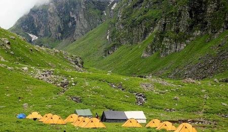
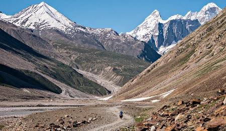
A gradual climb begins after Bhalu ka Gera (bears den). Balu ka Gera is known for wildflowers, rocks and caves. A further 1: 30 hrs.a trail takes you to Hamta pass. From Hamta pass you will have a fantastic view of Inderkila, Deo Tibba (6001m) and Indersan (6220m). The crossing of Hampta Pass brings to the Lahaul Valley. Walk down to the campsite set by the bank of the stream. Overnight stay will be at the camp.
(MEALS: BREAKFAST, LUNCH, DINNER)
On this day trek descends through the Hampta valley with easy descent, as you move closer to the road, the descent gets a little tricky. Cross the stream flowing by the camp and follow the other bank to the point where it joins the Chandra River. Now cross the Chandra river by a small wooden bridge. Now follow the left bank of Chandra River. The massive mountains of the Pir Panjal and Spiti ranges dominate the entire landscape till the campsite at Chhatru. Chhatru is a confluence point of paths from Rohtang Pass, Hamta Pass and Spiti. If road and weather condition permits to head to Chandra Tal campsite for camping after having hot lunch at Chatru, otherwise do camping in Chatru campsite. Overnight stay will be in the camp.
(MEALS: BREAKFAST, LUNCH, DINNER)
If trekkers had camped in Chandratal campsite then just after breakfast begin trekking for Chandra Tal which takes one and half hour, come back to the campsite before lunchtime and after lunch drive to Manali which takes 7 hours. If in day fifth trekkers had camped in Chatru then just after breakfast drive to Manali over Rohtang pass. Enroute a magnificent view of Hanuman Tibba peak (5990 meters). Stay for the night at the Hotel.
(MEALS: BREAKFAST, LUNCH, DINNER)
It is your last day in Manali. You are free to visit by own. At Evening time leave Manali by Volvo bus for Delhi.
(MEALS: BREAKFAST, LUNCH)
Accommodation on Double room for 02 nights in above mentioned hotel onFirst night on Full board basis while Last Night on Half board basis Accommodation in tents on double sharing basis Sleeping bags and mattresses during trek All meals as per itinerary. During the trek we will give you packed Lunch and provide evening snacks when you will reach camping area. Local Guides accompanying the group Staff: Guide, cook, helpers, trekking mules/horse or porters. All pre established camp sites as per the itinerary Camping & forest fees etc Medical first aid supply.
Alcoholic beverages and soft drinks. Personal laundry, Personal insurance. Personal Tipping to staff. Any unforeseen cost arises by natural hazards.
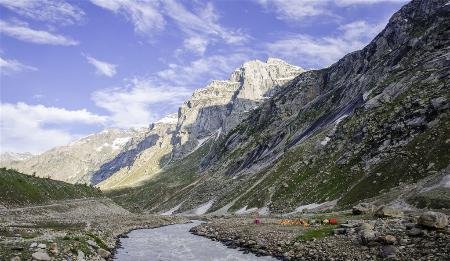
“Chandrataal” (4300M) Chandra Taal(Lake of the Moon) is situated at an altitude of about 4,300 metres (14,100 ft) in the Himalayas. Mountains of scree overlook the lake on one side, and a magnificent cirque presents a view on the other. The name of the lake originates from its crescent shape. Situated in the Spiti part of the Lahul and Spiti district of Himachal Pradesh (India), Chandra Taal is a popular destination for trekkers and campers. The lake is accessible on foot from Batal as well as from Kunzum Pass from late May to early October. There is also a motorable road from Batal which is 16 km (9.9 mi) away from Chandra Taal, but before August, its condition can be bad. The road fromKunzum Pass is accessible only on foot, and it is about 8 km (5.0 mi) from Chandra Taal. The most surprising thing about this lake is that there is no visible source of this lake but there is a visible outlet of this lake which means that water to this lake comes from underground. The lake is situated on the SamudraTapuplateau, which overlooks the Chandra River. The lake is one of two high-altitude wetlands of India which have been designated as Ramsar sites.